Introduction: Beyond the Drone Flight: What Matters is the Usable Report
Solar panels are a long-term investment, but their performance can decline annually due to hidden defects. A drone inspection is a fast and safe way to map the health of your installation. However, raw thermal images or a long list of photos are often insufficient for a manager or owner.
At Droneview.be, we know: the true value of an inspection is not in the flight, but in the structured report you receive. We ensure that every hotspot and defect is translated into a direct actionable step.
Step 1: Data Collection – What the Drone Sees
Our specialized drones (equipped with cameras such as the DJI Zenmuse XT2) collect two crucial data streams simultaneously:
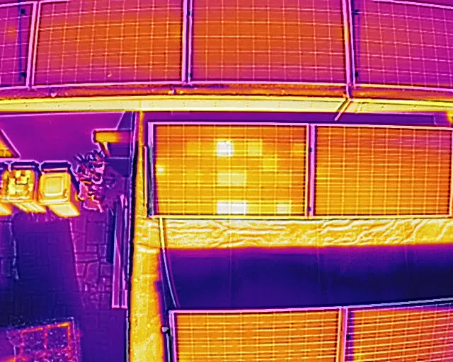
Thermal (IR) Images: These record heat differences. A defective solar cell, a broken bypass diode, or a poor connection emits heat and appears as a bright ‘hotspot’ in the image. This is the primary source of defect detection.
Visual (RGB) Images: These 4K images provide the visual context. They are essential for identifying physical damage (such as cracks) or contamination (such as bird droppings or leaves).
In addition, each image is provided with accurate GPS coordinates (Geotagging). This is the key to quickly locating and repairing defects on your large installation.
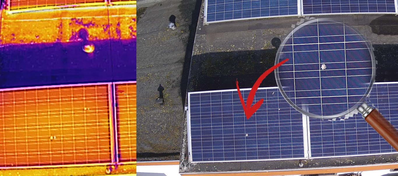
This example shows the crucial role of the dual sensor (thermal and visual). The thermal image (left) shows a clear hotspot, which could initially indicate a diode failure. Thanks to the simultaneous visual photo (RGB) (middle), the actual cause is immediately identified: a spot caused by bird droppings. The zoomed-in view (right) confirms this is a local shading issue rather than a permanent electrical defect, avoiding unnecessary repair costs. Droneview.be’s analysis filters out such ‘false positives’.
Step 2: The Analysis – From Hotspot to Defect
Once the flight is completed, the crucial analysis phase follows. Here we convert thermal anomalies into actionable findings. The most common defects we identify are:
Defect
Cause
Impact on Yield
1. Hotspots
Defective cell or broken bypass diode.
Limits current through the entire string; can pose a fire hazard.
2. Shading & Contamination
Shadow from objects or heavy dirt accumulation.
Direct yield loss in the affected area.
3. PID (Potential Induced Degradation)
Voltage differences and long-term moisture exposure.
Gradual but significant and permanent power loss.
4. Wiring Faults
Poor connections in junction boxes.
Local heat loss, indicating resistance and efficiency loss.
Why partnering with Droneview.be is smarter than investing in your own drone fleet
More and more property managers, developers, and contractors are considering purchasing their own drone for inspections. However, working with a specialized drone partner like Droneview.be often proves far more efficient, safer, and cost-effective.
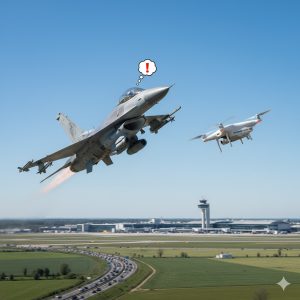
In recent weeks, drones have once again dominated the news. Illegal flights over military zones and even Brussels Airport (Zaventem) led to airspace closures. Understandably, both government and citizens are on high alert. Unfortunately, the consequences of these illegal flights are deeply affecting our legitimate operations. For professional drone pilots like us at DroneView.be, it’s becoming increasingly difficult to work safely and undisturbed.
When a Professional is Suddenly Seen as a Threat
We carry out essential daily inspections of rooftops, buildings, and solar panels—detecting thermal anomalies with precision equipment. All flights are performed legally under EU open category rules, at low altitude, and only under safe weather conditions.
Still, we often encounter public suspicion. Just days ago, during a rooftop inspection, someone shouted “I’ll shoot that drone out of the sky!”—despite our hi-vis vests, clearly marked van, and low, legal flight at 20 meters with a thermal camera. No privacy invasion, no dangerous flying—just professional work. And yet, the police were called.
Communication Starts with the Client
We always try to inform authorities properly: registration ready, pre-flight police notifications (especially during current tensions), clear signage on-site. But we’ve found that things run smoother when the client also informs nearby residents. A quick notice can prevent unnecessary panic or hostility.
The U.S. government is stepping up pressure on Chinese tech companies, and drone manufacturer DJI is increasingly in the spotlight. Several legislative proposals and investigations could lead to a partial ban on DJI drones in the United States.
But what does this mean for the rest of the world – and especially for Europe and Belgium? Will prices rise, deliveries slow down, or models disappear?
1. What’s happening in the United States?
In July 2025, the U.S. Department of Commerce launched a national security investigation into Chinese drones, including those made by DJI.
The new U.S. defense budget law also requires DJI to pass an audit before the end of 2025; otherwise, the company could be placed on the “FCC Covered List”, preventing certification and import of new models.
Consumers haven’t yet noticed much change, but manufacturers and distributors are already preparing for possible restrictions.
In recent weeks, drones have been spotted at sensitive locations across several European countries – from airports to energy infrastructures. In some cases, fingers were pointed towards Russia, although this remains unconfirmed.
What is clear is that governments are taking these incidents seriously. In Belgium too, drone surveillance is being tightened, especially near airports, military zones, ports, and border areas. In risk zones, authorities can now detect, intercept, or even disable drones more quickly.
What does this mean for regular drone pilots?
For both recreational and professional pilots, the rules remain the same — as long as you are properly registered and operate within the allowed zones.
However, it is now more important than ever to check before each flight whether you are allowed to fly and to request authorisation in time when operating in controlled or risk areas.
Step-by-step: how to check where you can fly in Belgium
Orange zones: specific conditions apply (altitude limits or prior authorisation)
Red zones: restricted or prohibited areas (CTR, military sites, nuclear plants…)
You can select either Open category or Specific category at the top, depending on your certification.
2. Check temporary restrictions (NOTAMs)
Some areas may be temporarily restricted for events, state visits, or military exercises.
Always check the NOTAMs via the skeyes AIM-METEO briefing.
Alternatively, use EAD Basic (EUROCONTROL) – free registration required.
If you need to operate in a controlled or military zone, submit your request via the DAA planner.
Drones are becoming increasingly popular in Belgium. They’re used for photography, video, inspections, mapping and even as a hobby. But many people still wonder: where can you fly, do you need to register, what are the rules, and what are the penalties if you don’t comply?
Vliegen met een drone in België kan een dure hobby worden als je de regels niet kent. Met boetes tot €10.000 en een verplichte registratie is een goede voorbereiding cruciaal.
This guide answers the most frequently asked questions about drone use in Belgium in 2026.
Looking for a worry-free drone solution?
Does the regulation seem complex, or do you want to ensure 100% legal, professional results for your business or project? At Droneview.be, we handle all the paperwork, flight permits, and insurance for you.
Streamline your site management with accurate 3D mapping.
Can you film freely with a drone?
Not entirely.
For private use it’s usually fine, provided you respect privacy.
For public places or commercial purposes, GDPR applies. At Droneview, we operate strictly according to these privacy laws for projects like real estate photography.
Drones under 250g, such as the DJI Mini series, fall into the least restrictive category.
No pilot license is required, but registration is mandatory (due to the camera).
While great for travel, these drones lack the sensors needed for professional tasks like thermal inspection of solar panels, where specialized industrial drones are necessary.
How high can you fly a drone in Belgium?
The maximum height is 120 metres.
Higher flights are only possible with special authorisation (SORA application). We regularly handle these permits for large-scale technical projects.
What are the penalties for breaking the rules?
Penalties can be heavy:
Flying in a no-fly zone: up to €10,000.
Flying without registration or license: €500 – €2,500.
What if a drone flies above my house or garden?
Stay calm – you are not allowed to intervene yourself.
Note details – time, drone type, and try to find the pilot.
Report it to the local police if you feel your privacy is being violated.
Is drone insurance mandatory in Belgium?
For professional use, liability insurance is mandatory.
You can rent a drone, but keep in mind insurance requirements and flight experience.
For professional projects, it’s often more cost-effective to hire a certified operator like DroneView.be. This eliminates the need for expensive equipment, software licenses, and time-consuming permit applications.
Do I need a drone license in Belgium?
It depends on the type of drone and the category of flight.
No license for drones under 250 g.
Online exam required for the Open Category (A1-A3).
Special flights often require STS or SORA authorisation.
Drones open up exciting possibilities, but the administrative and technical burden for professional use is significant. Want to ensure you avoid risks and receive high-quality data?
At DroneView.be, we strongly believe in collaboration within the Belgian drone sector. Professional pilots, training centers, insurers, and authorities all benefit from clear communication and united representation.
In early 2025, we decided to join the Belgian Drone Federation (BDF), convinced that an active federation could help move the sector forward.
Six months later, we regret to conclude that the federation appears to have gone completely silent.
What Membership Should Offer
According to the BDF’s official website, an annual membership of €199 (excl. VAT) should include:
Representation and advocacy for the drone sector
Networking with fellow professionals and entrepreneurs
Four newsletters per year
Free access to webinars
Discounts on BDF events and Van Dessel drone insurance
First-line advice on Open A1/A3, Open A2 & Specific categories
Company listing on the BDF website
Invitations to PRO events and roundtable sessions
On paper, a solid offer for professional drone operators.
The Reality
Unfortunately, the reality is quite different.
Since joining in March 2025, we have only received an automatic payment confirmation — no newsletters, no invitations, no updates, no communication at all.
After several attempts to reach out — via email, social media, and directly to board members — we received no reply. Even simple questions went unanswered.
After six months, it seems clear that the federation has ceased to operate actively.
More and more drone pilots hear the term Remote ID, but few know exactly what it means. Since 2024, a Remote ID beacon has become essential: a small module that acts as the digital license plate of your drone. In this article we explain how such a beacon works and why it is also the solution for older drones.
What is a Remote ID beacon?
A Remote ID beacon is a lightweight transmitter that you easily attach to your drone. The device continuously broadcasts important data via Bluetooth, such as:
your operator ID (the official registration number of the pilot),
the position and altitude of the drone,
the position of the pilot.
This allows anyone with the right app or scanner to immediately see who is flying and where.
How does it work in practice?
The beacon is completely stand-alone:
it has a built-in GPS antenna to determine its position,
a built-in rechargeable battery (lasting 8–16 hours) that you recharge via USB-C,
a simple mounting system with Velcro or tape so you can attach it to almost any drone.
You don’t need to modify your drone: the beacon does all the work itself.
Example: the Dronetag Beacon
One of the most popular models is the Dronetag Beacon:
weight: only 16 grams,
battery life: up to 16 hours,
user-friendly: settings via an app on your smartphone,
compliant with EU standards, fully legally approved.
Thanks to the built-in GNSS receiver you don’t need extra antennas or cabling.
In the fast-evolving world of real estate, standing still is not an option.
Potential buyers and tenants expect more than static photos and descriptions.
They want to get a realistic sense of a property before scheduling an in-person viewing.
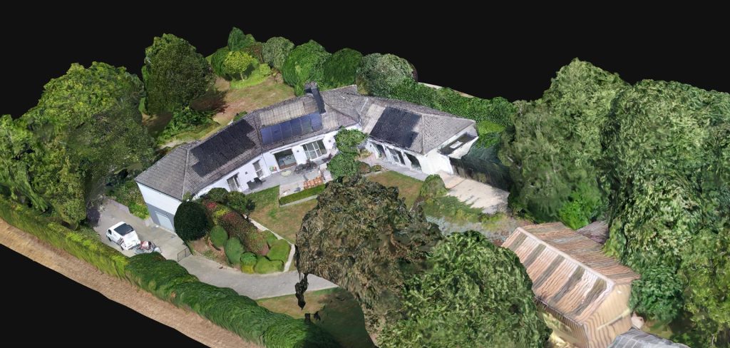
3D real estate scans offer exactly that.
At DroneView.be, we use this technology to elevate property presentations to a higher level. This article explains how 3D scans work, what advantages they offer, and why they are quickly becoming the new standard in real estate marketing.
What is a 3D Visualisation of a Property?
A 3D visualisation is a virtual model of an existing building, created by capturing dozens to hundreds of aerial and façade images. These images are processed using specialised software such as WebODM to generate an accurate and detailed 3D model. The result is a digital twin of the property that provides far more insight than traditional media.
The visualisation consists of two key components:
2D orthophoto: A scale-accurate top-down image of the property and its surroundings, offering a clear view of the layout and dimensions.
3D model: An interactive representation that visitors can rotate, zoom and explore on any device, providing a 360° virtual tour directly from your own website.
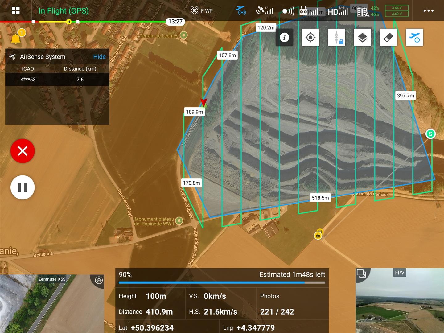
At DroneView.be, we do more than capture spectacular aerial photos. We transform drone imagery into measurable, actionable data for our clients. Traditional inspections and land surveys, especially across vast areas like quarries, are time-consuming, risky, and often inaccurate. Our recent project in a quarry perfectly illustrates how drone mapping streamlines this process. From 1,750 individual photos, we created an interactive 3D model, enabling the client to easily perform volume calculations and efficiently manage the site.
Case Study: Precision in the Quarry
The Project: Our client, a quarry operator, needed an accurate, up-to-date overview for material management and strategic planning. Covering more than 100 hectares, manual surveying was impossible. DroneView.be conducted a series of automated drone flights, resulting in a dataset of 1,750 images.
Our Approach: Mission Flights
For a site of this size, preparation is crucial. We plan about ten mission flights, partly from the office and partly on-site. Each flight is carefully configured to systematically capture the entire area with proper overlap. The structured pattern ensures that all images can later be seamlessly processed into one complete 3D model in WebODM.