Accurate Inventory of Bulk Materials with Drones

Do you truly know how much stock you have?

Many companies storing bulk materials—sand, gravel, ores, crushed stone, or waste streams—face the same challenge: the actual inventory is never quite certain. Traditional measurement methods are time-consuming, labor-intensive, and often inaccurate. The result? Uncertainty during audits, inefficient logistics, and potential financial risks.

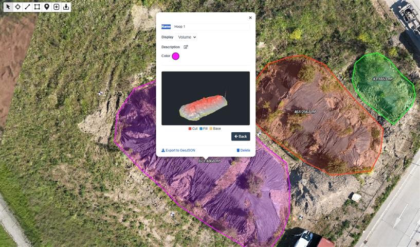
Droneview.be offers a modern solution with professional drone technology and RTK precision.


Why traditional inventory falls short

With classic stockpile measurements, employees are deployed to climb heaps, take manual readings, or make estimates based on delivery notes. This entails three concrete problems:

  • Safety Risks: Climbing large stockpiles is dangerous and falls under preventive workplace safety concerns.
  • Time Loss: A full inventory of a large site can take days to complete.
  • Inaccuracy: Manual measurements or visual estimates can result in discrepancies of 5 to 15%—which has a significant financial impact on large volumes.

3D mapping of stockpile measurement with drone and Volume measurement of bulk materials via RTK drone

Continue reading “Accurate Inventory of Bulk Materials with Drones”

Maintaining & Upgrading Drones: Our Experiences and Practical Tips

We are always focused on keeping our drones in top condition through maintenance and upgrades. In this article, we share how we maintain our drones and the tips we personally apply. At the end, you’ll find our handy maintenance checklist—hopefully, you’ll find value in the insights we share!

Our Basic Drone Maintenance Principles

Regular Inspections

Before every flight, we conduct a thorough visual inspection of our drones. We check for visible damage, loose components, and signs of wear. We also ensure that our sensors and cameras are clean, allowing us to achieve optimal performance at all times.

Battery Maintenance

We strictly follow the recommended charging cycles and avoid overcharging or completely draining our batteries. We also store them in a cool, dry place, which not only extends battery life but also ensures consistent flight performance.

Firmware and Software Updates

Keeping firmware and software up to date is a must for us. This ensures we benefit from the latest features, flight safety improvements, and bug fixes. We schedule updates and test them carefully before using our drones again.

Continue reading “Maintaining & Upgrading Drones: Our Experiences and Practical Tips”

“Make Drones Great Again?” – What if Trump Launches a Drone Next?

Red, White & Drone: Is the Trump Drone Really on Its Way?

In a world where marketing often speaks louder than technology, something curious just took off in the American media landscape: the Trump Phone. Yes, the president (or at least his sons) launched their own smartphone—complete with a mobile network. And while the tech world was choking on its coffee, we at Droneview.be couldn’t help but wonder: is a Trump Drone next?

The Trump Phone: Patriotism in a Chinese Package

First, claim that American companies are too powerful. Then attack the competition. And finally launch your own “Made in the USA” smartphone… which turns out to be made in China. Welcome to the Trump Phone: an overpriced Android device drenched in patriotic flair and marketing that promises more than it delivers.

Until you dig a little deeper,..

Continue reading ““Make Drones Great Again?” – What if Trump Launches a Drone Next?”

Live Monitoring During Our Drone Flights: An Extra Service for Our Clients

At DroneView.be, we are constantly striving to improve our services. We understand how important it is to have real-time insights during an inspection or search and rescue operation. That’s why we have recently added an external 32” monitor to our equipment, allowing you to follow our drone flights live.

Why an External Monitor?

During construction inspections, the monitor provides immediate visual access to the images captured by the drone. This allows you to assess project progress on-site and take action if necessary. Not only does this simplify decision-making, but it also ensures greater transparency and involvement.

In search and rescue operations, speed is crucial. By following the live images directly on the monitor, rescue teams and stakeholders can immediately respond to what the drone captures. This saves valuable seconds and enables faster action.

Continue reading “Live Monitoring During Our Drone Flights: An Extra Service for Our Clients”

DJI Zenmuse Z30: Ultimate Zoom Capability for Drone Inspections

At Droneview.be, we use the DJI Zenmuse Z30 for detailed drone inspections requiring extreme zoom. With 30x optical zoom and 6x digital zoom, this camera provides unparalleled capabilities for inspecting infrastructure, buildings, and industrial facilities without bringing the drone dangerously close.


Why Choose the Zenmuse Z30?

The Z30 is designed for professionals working in inspection, security, and monitoring. Its main advantages include:

  • Extreme detail without risk: Thanks to its powerful zoom, we can capture small details from a safe distance, such as cracks in a tower or loose bolts on a wind turbine.
  • Efficiency: Traditional inspections often require scaffolding or rope access. With the Z30, we can complete a thorough visual inspection in minutes.
  • Fast data collection: High-resolution images from a distance allow for quick assessments and faster decision-making.

Continue reading “DJI Zenmuse Z30: Ultimate Zoom Capability for Drone Inspections”

Drone deployed for missing dog search

At DroneView.be, we usually use our drones for inspections and analyses, but sometimes, we receive unusual requests. Recently, we were called in to assist in the search for a missing dog.

The dog had been missing for 48 hours, and the owner had tried everything to find it. After two days of unsuccessful searching, they decided to use a drone to expand the search area and improve their chances. Thanks to our specialized drones and experience in detecting hard-to-spot objects, we were able to systematically scan the area.

Our drone with a thermal imaging camera proved invaluable. In wooded or hard-to-reach areas, a drone can quickly cover a large space and detect heat sources invisible to the naked eye.

Continue reading “Drone deployed for missing dog search”

Why new solar panel installations should also be tested

At Droneview.be, we regularly inspect older solar panel installations to detect defects and efficiency losses. However, we recently encountered an unexpected issue at a client’s site: a brand-new installation from November 2024 had three panels with faulty cells. This proves that testing is not only essential for older systems but also for new installations.

Defects in new panels: how is this possible?

Although you’d expect new solar panels to work flawlessly, defects can occur during manufacturing, transport, or installation. The three defective panels in this installation had damaged cells, which can lead to:

  • Reduced energy output: A single defective panel can negatively impact the entire string’s performance.
  • Higher internal resistance and heat buildup: This can shorten the panel’s lifespan and pose safety risks.
  • Potential warranty issues: If defects are not detected in time, claiming warranty replacements can become more complicated.

Continue reading “Why new solar panel installations should also be tested”

Construction Site Monitoring with Our DJI Drones: How We Help You Save Time and Money

How we, as drone specialists, make your project smarter, safer, and more efficient

At Droneview.be, we’ve been monitoring construction sites for years with our professional drones: a DJI M210 (equipped with a Z30 zoom camera and an XT2 thermal camera) and an Inspire 2 (with a sharp X5S camera). For project developers and contractors, this means: no hassle with flying yourself, but clear insights that prevent delays and save money. Below, we explain how we handle this for you.

Why choose us for construction site monitoring?
No investment needed: We provide the drones, pilots, and software.
Tailored expertise: Our M210 and Inspire 2 are perfect for:

  • Sharp details: The Z30 camera zooms in from 20m to inspect cracks or loose bolts.
  • Thermal inspections: The XT2 camera detects insulation leaks or electrical issues.
  • Precision measurements: The Inspire 2 creates high-quality 3D maps for volume determinations.
  • Certification in order: Our pilots hold the required A1/A3 certificate and comply with all Belgian drone regulations.

Continue reading “Construction Site Monitoring with Our DJI Drones: How We Help You Save Time and Money”

Discover the Power of WebODM

Are you intrigued by drone mapping and wondering how to process aerial imagery into insightful data? WebODM is an open-source platform that makes processing and analyzing drone data accessible and efficient. Whether you’re working on construction projects, monitoring agricultural land, or documenting heritage sites, WebODM provides professional-grade results for a wide range of applications.

Applications of WebODM

3D Models
Generate highly detailed and interactive 3D models from drone imagery. This is ideal for visualizing project sites, conducting architectural analyses, and even heritage preservation.

  • Orthomosaic Maps
    Stitch together aerial images into precise orthomosaic maps for large-scale analysis in industries like agriculture, urban planning, and environmental monitoring.
  • Volume Calculations
    Accurately measure material volumes, such as soil or debris, which is invaluable for mining and construction projects.
  • Analysis and Inspections
    Identify potential issues such as erosion, infrastructure damage, or drainage problems with WebODM’s analytical tools.

Continue reading “Discover the Power of WebODM”

Transform Your Projects with 3D Scans and Data Analysis from DroneView.be

The world of project planning and inspection is evolving rapidly. Thanks to advanced technologies, we can now collect and visualize data in ways that were previously unimaginable. At DroneView.be, we leverage these innovations to provide you with detailed insights that elevate your projects to the next level.

Why Choose 3D Scans and Advanced Analysis?

Our services go far beyond capturing aerial imagery. With our expertise in 3D scans and data analysis, you can rely on accurate results and scalable solutions. From volume calculations to inspections, our methods are designed to make your processes more efficient and effective.

Continue reading “Transform Your Projects with 3D Scans and Data Analysis from DroneView.be”