DJI M30T at Droneview.be: Compact Inspection Drone with Centimeter-Level Precision

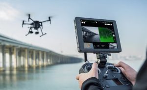
With the deployment of the DJI Matrice 30T, Droneview.be strengthens its services in professional drone inspections, surveying support and data-driven site monitoring.

This drone is not a traditional upgrade, but an integrated measurement platform combining inspection, mapping, thermography and distance measurement in one robust system.

For construction projects, property developers and architects where every centimeter matters, this technology makes a measurable difference.

For complex projects where every centimeter counts, the M30T truly makes the difference.


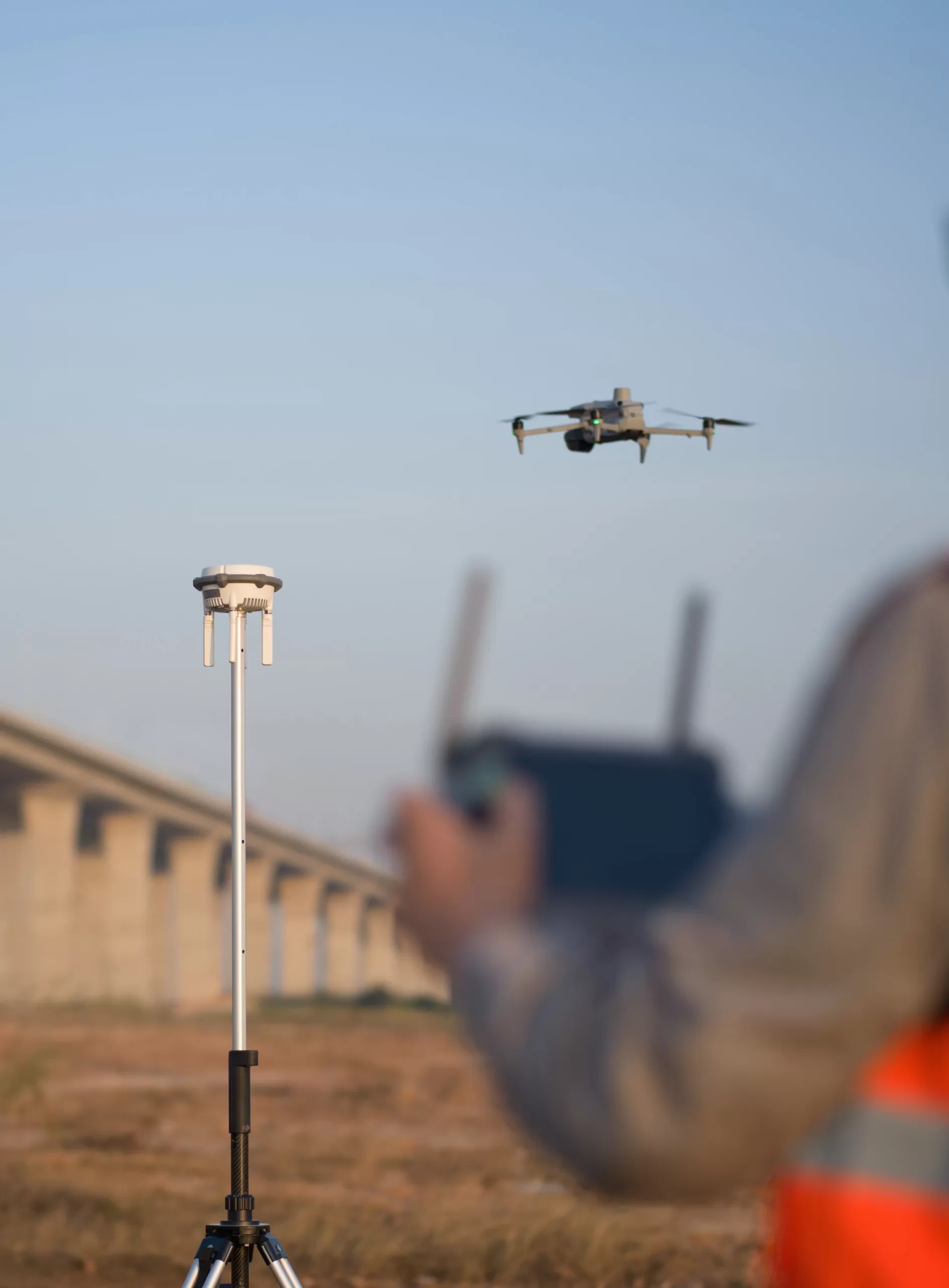
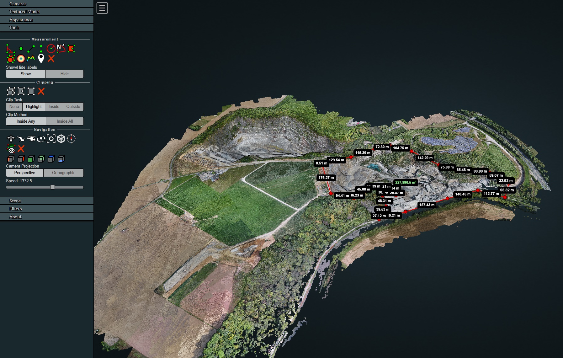
Centimeter-level mapping accuracy thanks to our own RTK station and FLEPOS

The M30T features built-in RTK (Real-Time Kinematic). For maximum accuracy, Droneview.be operates with a professional in-house RTK base station, connected to the Belgian FLEPOS reference network.

This combination allows us to achieve positioning accuracy of 1 to 3 centimeters, fully compliant with surveying standards.

Using our own RTK station means:

  • Independent and stable correction signals
  • Reliable operation in areas with limited network coverage
  • Consistent measurement quality across multiple projects
  • Reproducible datasets for periodic measurements
  • This translates concretely into:
  • Setting out and verifying earthworks
  • Volume calculations of excavations and storage areas
  • Parcel analysis for subdivisions and developments
  • Digital Elevation Models (DEM) for drainage and sewer studies
  • 3D terrain models for architectural integration
  • As-built verification and comparison with design plans

Engineering firms and architects receive reproducible measurement data directly usable for further engineering.

Thanks to RTK support, the number of ground control points is reduced, speeding up site acquisition and improving processing efficiency.


RTK applications beyond drone flights

Our RTK base station is not exclusively used for drone flights. The system can also be deployed independently for precision positioning and ground-based surveying.

Possible applications:

  • Surveying reference and control points (GCPs)
  • Setting out building lines and axes
  • Foundation height verification
  • Positioning utilities and technical infrastructure
  • Preparation of surveying documentation
  • Support for subdivision and infrastructure projects

For developers, contractors and architects, this means one integrated measurement system can be used throughout all project phases: from design and earthworks to final delivery.

By combining aerial data and ground measurements, a coherent and verifiable measurement framework is created, significantly reducing discussions about heights, volumes or positioning.


Support for property development and architecture

For developers and architects, the M30T offers key advantages in both the design and execution phases:

Preliminary design & feasibility studies

  • Detailed terrain analysis
  • Contour lines and slope gradients
  • Integration of buildings into existing topography

Execution phase

  • Verification of staked foundations
  • Earthmoving monitoring
  • Design vs. construction comparison

Delivery phase

  • As-built 3D models
  • Documentation for technical files

This allows a large part of site verification to be carried out digitally and objectively, without permanent presence on site.


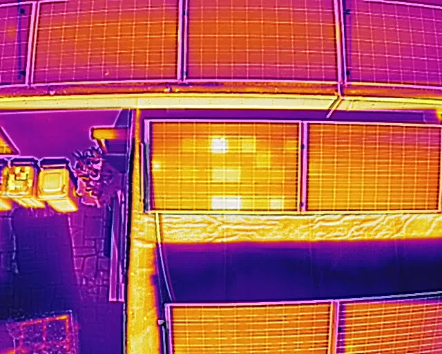
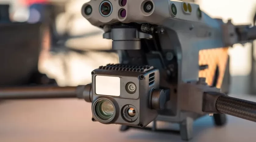
Triple-camera system: visual, thermal and zoom in one flight

What makes the M30T unique is the integration of multiple sensors in one compact payload.

During a single mission we automatically capture:

  • Wide images
  • Zoom images
  • Thermal images

Wide Camera

  • 12 MP
  • 1/2” CMOS sensor
  • Ideal for overview and mapping

Zoom Camera

  • 48 MP
  • 5x optical zoom
  • Up to 16x hybrid zoom
  • Up to 200x maximum digital zoom

For inspections of masts, wind turbines, facades or industrial installations, we remain at a safe distance while still analyzing microscopic details.


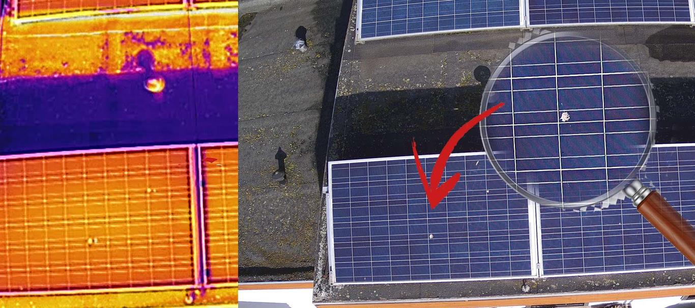
High-Res Grid: extreme resolution without risk

With the High-Res Grid function, the drone automatically scans a selected area and combines multiple 48 MP zoom images into one ultra-high-resolution image.

Result:

  • Exceptional level of detail
  • No risk from flying close to structures
  • Ideal for facade inspections and technical analysis

Continue reading “DJI M30T at Droneview.be: Compact Inspection Drone with Centimeter-Level Precision”

Planning and requesting drone flights in Belgium: The Complete Guide

Flying a drone in Belgium is no longer a matter of “just taking off”. Whether you fly recreationally or carry out professional missions for inspections, construction sites or real estate, proper preparation is essential. Ignoring the rules can lead not only to fines, but also to your flight being stopped on site.

In this article, we explain step by step how to:

  • check whether you are allowed to fly at a specific location
  • determine whether an official request is required
  • correctly submit a flight via the Drone Service Application (DSA)
  • know what to do on the day of the flight

This article builds on our earlier explanation of GeoZones and drone legislation in Belgium.

That basic knowledge remains important and can be read here:
https://www.droneview.be/en/stricter-drone-control-in-europe-how-to-check-where-you-can-fly-in-belgium/

Step 1: First check where you are allowed to fly – Droneguide

Every drone flight starts with one simple question: am I allowed to fly here?

The official map for this is the Droneguide map from skeyes.

Go to: https://map.droneguide.be

On this map, you can immediately see:

  • prohibited zones (no-fly zones)
  • warning zones
  • zones with specific conditions (such as around airports, industry, ports or military areas)

Zoom in on your planned location and click on the zone. You will immediately receive additional information about:

  • the type of GeoZone
  • who manages the zone
  • whether an authorisation is required

Important to remember:

The Droneguide map is an information tool.
It tells you whether flying is allowed, but it does not grant permission.

If you see that your location is in a GeoZone managed by skeyes (such as VLL zones around airports), a request via the DSA is mandatory.

Step 2: When do you need the DSA Planner?

Continue reading “Planning and requesting drone flights in Belgium: The Complete Guide”

The DJI M210: our trusted workhorse in the sky

It may not be the newest drone in DJI’s lineup, but the Matrice 210 continues to prove its worth. At DroneView.be, this robust drone remains a reliable choice for clients who demand precision, flexibility, and consistent performance in the air.

A drone that gets the job done
The DJI M210 is built for tough tasks. Whether it’s roof inspections, industrial sites, solar panels, or hard-to-reach infrastructure – this drone handles it all. It also performs well in challenging weather conditions: rain, wind, cold – the M210 keeps flying.

Modular and multifunctional

Continue reading “The DJI M210: our trusted workhorse in the sky”

From Data to Report: How We Deliver Drone Inspection Data in a Structured Way (and What Clients Really Need)

Introduction: Beyond the Drone Flight: What Matters is the Usable Report


Solar panels are a long-term investment, but their performance can decline annually due to hidden defects. A drone inspection is a fast and safe way to map the health of your installation. However, raw thermal images or a long list of photos are often insufficient for a manager or owner.

At Droneview.be, we know: the true value of an inspection is not in the flight, but in the structured report you receive. We ensure that every hotspot and defect is translated into a direct actionable step.

Step 1: Data Collection – What the Drone Sees


Our specialized drones (equipped with cameras such as the DJI Zenmuse XT2) collect two crucial data streams simultaneously:

  1. Thermal (IR) Images: These record heat differences. A defective solar cell, a broken bypass diode, or a poor connection emits heat and appears as a bright ‘hotspot’ in the image. This is the primary source of defect detection.
  2. Visual (RGB) Images: These 4K images provide the visual context. They are essential for identifying physical damage (such as cracks) or contamination (such as bird droppings or leaves).

In addition, each image is provided with accurate GPS coordinates (Geotagging). This is the key to quickly locating and repairing defects on your large installation.

This example shows the crucial role of the dual sensor (thermal and visual). The thermal image (left) shows a clear hotspot, which could initially indicate a diode failure. Thanks to the simultaneous visual photo (RGB) (middle), the actual cause is immediately identified: a spot caused by bird droppings. The zoomed-in view (right) confirms this is a local shading issue rather than a permanent electrical defect, avoiding unnecessary repair costs. Droneview.be’s analysis filters out such ‘false positives’.

Step 2: The Analysis – From Hotspot to Defect


Once the flight is completed, the crucial analysis phase follows. Here we convert thermal anomalies into actionable findings. The most common defects we identify are:

Defect Cause Impact on Yield
1. Hotspots Defective cell or broken bypass diode. Limits current through the entire string; can pose a fire hazard.
2. Shading & Contamination Shadow from objects or heavy dirt accumulation. Direct yield loss in the affected area.
3. PID (Potential Induced Degradation) Voltage differences and long-term moisture exposure. Gradual but significant and permanent power loss.
4. Wiring Faults Poor connections in junction boxes. Local heat loss, indicating resistance and efficiency loss.

Continue reading “From Data to Report: How We Deliver Drone Inspection Data in a Structured Way (and What Clients Really Need)”