
High-Precision 3D Mapping of Large-Scale Industrial Areas
This is an example of a project we recently completed for a client: an entire quarry was mapped using 1,750 drone photos and hours of intensive computer processing. The result is an interactive 3D model that allows the client to carry out precise measurements and gain valuable insights.
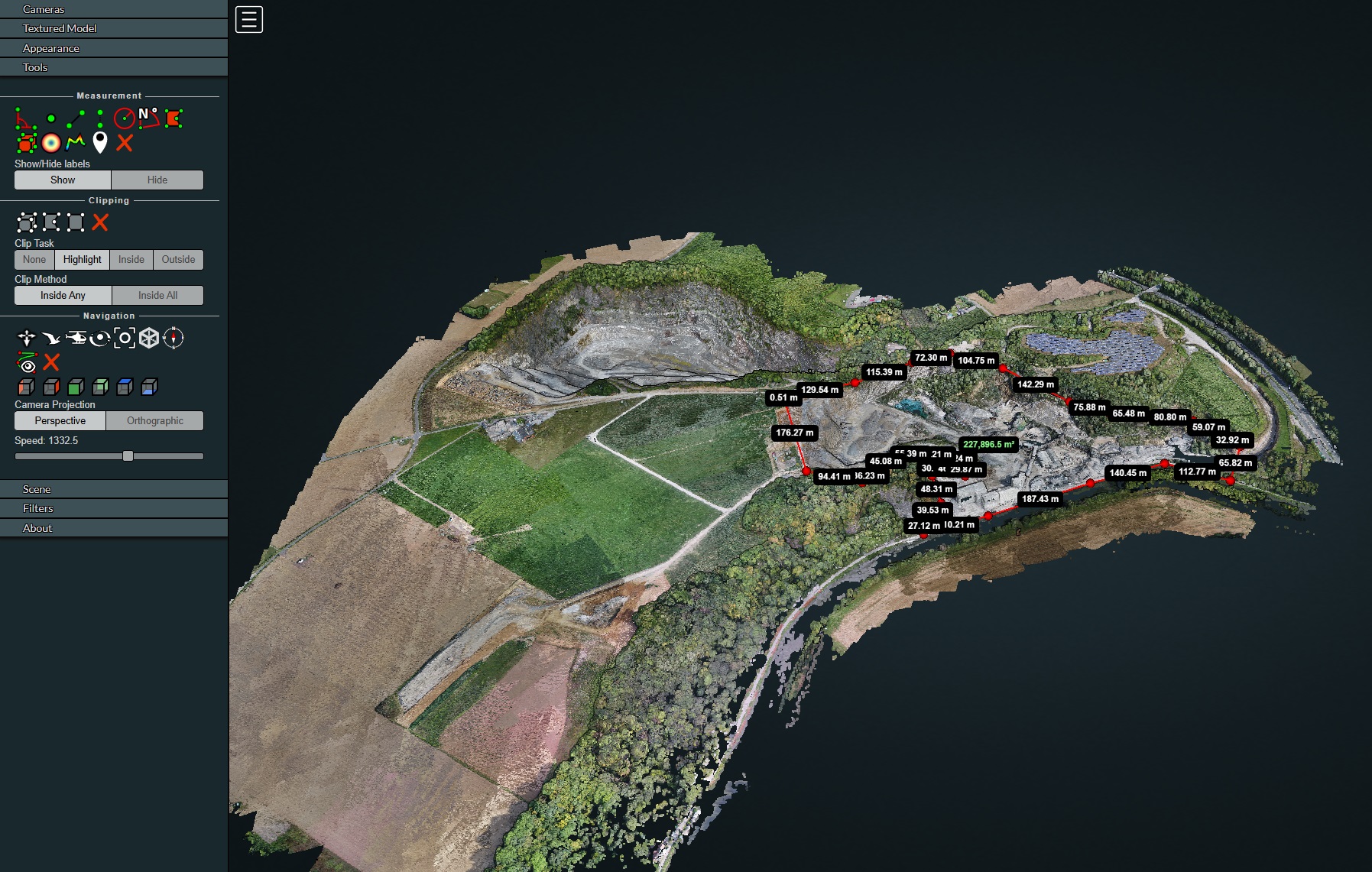
From Raw Data to Actionable Insights Our scans are performed using RTK precision for centimeter-accurate results. Want to explore the interface? We’ve set up a full project for you to test our WebODM viewer.
DroneView.be – Turning Drone Images into Clear Insights
At DroneView.be, we don’t just capture drone images—we turn them into clear, actionable data. Whether you’re overseeing a construction site, managing farmland, or documenting heritage buildings, we help you see the full picture and make confident decisions.
What We Can Do for You
Detailed 3D Models
Need a realistic model of your project site? Our 3D scans are ideal for architects, contractors, and conservation experts. They make planning, reporting, and collaboration fast and visual—no guesswork, just clarity.
Orthomosaics & Scaled Maps
Our drone maps are razor-sharp, scalable, and accurate. Perfect for surveyors, urban developers, and farmers. Whether you’re managing fields in West Flanders or planning roads in Brussels, we deliver precision you can rely on.
Accurate Volume Calculations & Stockpile Management
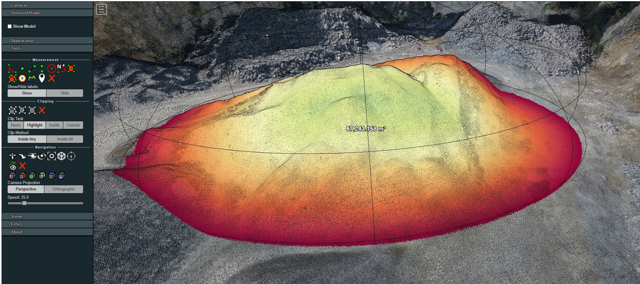
Using our advanced photogrammetry software, we transform drone data into highly precise volume measurements. While traditional land surveys are often based on a limited number of sample points, our drones generate a ‘point cloud’ consisting of millions of data points. This results in a digital terrain model that accounts for even the smallest irregularities in a pile of sand or debris. We provide a complete digital twin of your entire site in a user-friendly cloud environment. Whether there is one large stockpile or dozens of different types of construction materials, the entire site is mapped in meticulous detail.
Direct Insights via Your Browser
You gain access to an interactive platform without the need to install heavy software. Using just your standard web browser, you can:
- Perform your own measurements: Calculate the volume of any stockpile, determine the exact height of a depot, or measure distances between objects on-site with just a few clicks.
- History & Comparison: Track the progress of your inventory by comparing different surveys over time.
- Easy Sharing: Share specific measurements or the complete 3D model directly with colleagues, site managers, or clients via a simple link.
Why Choose Digital Volume Measurement?
- Speed & Safety: No more surveyors climbing over unstable piles. Measurements are taken from a distance without interrupting site operations.
- High Precision: Thanks to our RTK technology, we achieve centimeter-level accuracy, which is essential for correct inventory and invoicing.
- Visual Reporting: You receive more than just a number; you get a detailed 3D visualization and heat maps as shown above.
Applications Across Various Sectors:
- Earthworks & Demolition: Accurate determination of excavated soil or debris to be processed on large sites.
- Quarries & Sand Pits: Monthly or annual inventory of stock for accurate accounting.
- Bulk Material Handling: Management of gravel, sand, aggregates, or coal stocks in ports and industrial sites.
- Recycling & Waste Management: Monitoring landfill capacity or the volume of recycled fractions.
- Logistics & Bulk Goods: Rapid inspection of bulk inventories in warehouses or outdoor areas.
Inspections & Problem Detection
Spot issues before they become expensive. We use high-resolution imagery and smart analysis to detect erosion, water pooling, structural damage, and more—so you can take action early.
Full Web Version: No Software Required!
One of the main advantages of our service is the flexibility in delivery. All generated data – the 3D model, orthophotos, and terrain models – can be provided on request in a full web version. This means clients do not need any special software to view or use the results. Everything is directly accessible via a browser, making it easy to share with colleagues, partners, and other stakeholders. 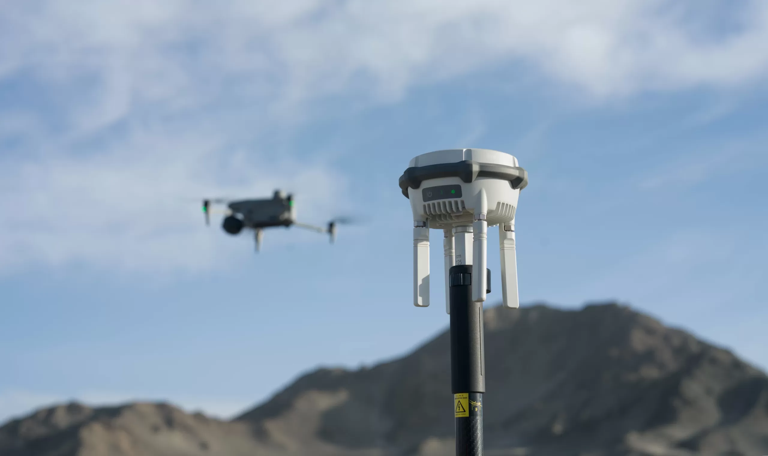 RTK-3 Base + M30T drone[/caption]
At DroneView.be, we use our own RTK base station, which provides centimeter-level accuracy for all our drone flights, including 3D mapping, volume calculations, and terrain modeling. This high precision allows us to deliver reliable datasets for project developers, architects, engineering offices, and contractors, with both visual inspections and measurable coordinates available.
The RTK station can also be used independently from the drone for ground measurements and terrain adjustments.
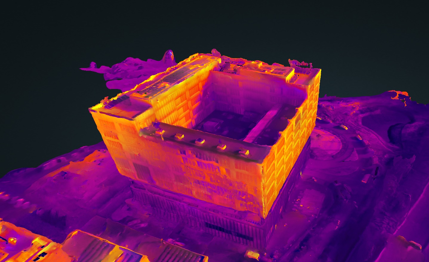
Thermal Digital Twins: Large-Scale Inspections
In addition to visual mapping and volume measurements, we now apply our Digital Twin technology to large-scale thermal inspections. This is particularly valuable for extensive solar farms or large industrial complexes where manual inspection is no longer feasible.
From 1,000+ images to one clear overview In a traditional inspection of a solar farm with thousands of panels, it is easy to lose track among hundreds of individual thermal images. By processing these images into a Thermal Digital Twin, we create an integrated navigation system.
-
Asset Management: Locate defects as small as 10×10 cm (such as hotspots or string failures) directly within the 3D model.
-
Pixel-precise data: Click on any anomaly in the viewer to immediately open the underlying radiometric data (R-JPEG) for detailed temperature analysis.
-
Efficiency: Maintenance teams no longer need to search; they are guided directly to the problem with exact coordinates and visual screenshots.
This innovative method transforms a complex mountain of data into an action-oriented management tool, essential for maximizing the yield of large-scale installations.
Reporting & Certification
Our thermographic drone inspections and Digital Twins provide objective measurement data and visual evidence that can be directly integrated into BREEAM files and sustainability studies. We provide the necessary legends, technical parameters, and radiometric data required by auditors.
Examples of applications:
- Setting out earthworks and foundations
- Accurate parcel measurements for subdivisions or construction projects
- Verification of height differences and terrain models
- Support for infrastructure planning and civil works
- Reference point determination (GCP) for follow-up measurements with drones or traditional surveying methods
By combining aerial measurements with the M30T and ground-based RTK support, a complete and verifiable measurement framework is created, enabling projects to be executed faster, safer, and more efficiently.
Who We Work With
Construction & Infrastructure
Track progress, calculate volumes, and visualize plans with 3D models tailored to your site.
Agriculture
Improve crop management with NDVI maps and soil insights—data that actually helps you grow smarter.
Heritage & Conservation
Capture historic sites in high detail with 3D scans that support restoration and documentation.
Environmental Monitoring
Analyze land changes, waterways, and natural erosion with drone data that brings clarity from above.
Why Choose DroneView.be?
We combine high-end drone tech with practical, real-world experience in the field. From thermal inspections to orthophoto mapping, we’ve helped contractors, farmers, and public services across Belgium get the data they need—fast, reliable, and fully tailored.
3D Mapping for Industry & Project Development Map your entire site with an unprecedented accuracy of 1 centimeter. Thanks to our advanced DJI M30T drone and our own RTK base station, we deliver more than just images—we provide measurable data.
-
No software required: View your 3D models and perform volume measurements directly in your browser via our WebODM Cloud platform.
-
Accessible anywhere: Consult your digital twin at the office for engineering tasks or on a tablet during site inspections.
Read here how we transform industrial sites with 3D Mapping and Cloud insights →
Let’s Talk
Curious how we can help your project?
Whether you’re working on a building site, farmland, or cultural monument—reach out today and let’s explore what drone data can do for you.
Contact us for advice or what we can do for you.