Make the most of your environment
With our drone‑based 3D scans you can capture every terrain or building down to the smallest detail. No more time‑consuming measurements or confusing 2D plans, but a digital representation that you can use right away. Choose the block that best suits your project:
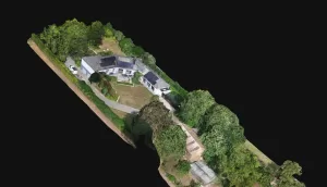
Real Estate 3D scans – bring property to life
For real estate agencies and developers we create photo‑realistic 3D models and 2D orthophotos of houses or commercial properties. Potential buyers can view a property in 360°, rotate and zoom directly on your website without exposing the address or privacy‑sensitive details.
Read more about real estate 3D scans
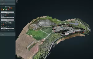
3D measurements & analysis – accuracy down to the centimetre
For contractors, architects, farmers and heritage managers we offer precise 3D measurements and analyses. We create digital terrain models, scaled orthophotos and volume calculations that let you monitor progress, plan and report. We deliver the data via a secure online viewer and – if desired – as a local file.
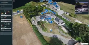
Learn how to use our 3D viewer – WebODM guide
Wondering how to measure distances, areas or volumes yourself in our 3D model? In our comprehensive guide we explain step by step how to use the viewer: from viewing orthophotos and camera positions to making annotations and exporting data. Ideal to get the most out of your 3D scan.